Landsat Next Defined

Landsat Next Defined

Landsat Next is on the horizon—the new mission will not only ensure continuity of the longest space-based record of Earth’s land surface, it will fundamentally transform the breadth and depth of actionable information freely available to end users. Take a look at the new capabilities that will define the next Landsat mission.

Read More »

Expanding OpenET Across Amazon Basin

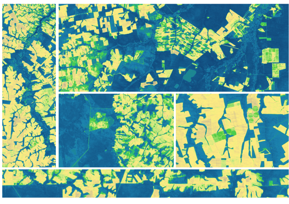
The research teams who help sustain the largest freshwater reserve in the world are developing a new tool to promote more resilient farming systems in Brazil. The goal is to help farmers better handle changes in the water cycle, deal with droughts, and adapt to a changing climate.

Read More »
Landsat Next Defined

Landsat Next Defined

Landsat Next is on the horizon—the new mission will not only ensure continuity of the longest space-based record of Earth’s land surface, it will fundamentally transform the breadth and depth of actionable information freely available to end users. Take a look at the new capabilities that will define the next Landsat mission.

Read More »

Expanding OpenET Across Amazon Basin

The research teams who help sustain the largest freshwater reserve in the world are developing a new tool to promote more resilient farming systems in Brazil. The goal is to help farmers better handle changes in the water cycle, deal with droughts, and adapt to a changing climate.

Read More »

“From now on, we’re going to be able to track all of the different types of changes in glaciers – there’s so much science to extract from the data.”


“We live on this planet Earth. We all know that we want to leave this planet for our children. We know the importance of sustainability and I think that’s what Landsat’s all about. It’s about helping us manage the planet that we live on for the long-term. And that’s why it’s there and that’s why it continues to be here. And I expect it to be there for the next generation as well.”


“We are very excited to employ integrated Landsat and Sentinel-2 data. The combined observations provide an unprecedented capability and, we expect, an unprecedented record of global land change.”


“It’s really a new era for Landsat, in that we’re going to have two observatories with very similar capabilities and very similar—if not identical—performances operating together. And this is going to provide more data to the Landsat mission than we’ve ever had before.”


“Thanks to Landsat, we were able to dramatically improve our satellite base map in Google Earth and Google Maps on two separate occasions, first in 2013, and again in June 2016. Our most recent 15 meter-per-pixel global mosaic was made from over 1.5 million Landsat 7 and Landsat 8 images and forms the view of Earth you see across our mapping products for the first twelve zoom levels of the imagery basemap.”


“Landsat is widely considered to be a crucial national asset, comparable to the satellite-based GPS system and National Weather Service satellites. Ready access to Landsat images supplies a reliable common record of Earth conditions that fosters the mutual understanding of environmental challenges by citizens, researchers, and decision makers worldwide.”


“I don’t think people appreciate just how revolutionary it was when the Landsat archive became available for free and really empowered researchers and advocates to have access to that data at an affordable price to be able to do the kind of mapping that’s now been done, making visible what was previously invisible…”


“Continuing the critical observations made by the Landsat satellites is important now and their value will only grow in the future, given the long term environmental changes we are seeing on planet Earth.”


“Timelapse in Google Earth simply wouldn’t have been possible without NASA and the United States Geological Survey’s Landsat program, the world’s first (and longest-running) civilian Earth observation program, and the European Union’s Copernicus program with its Sentinel satellites.”


“The availability of continuous data streams of high quality and free of charge satellite observations such as the Sentinels of the European Copernicus program and the Landsat missions, in combination with the emergence of automated methods for large data processing and data analytics, and the democratization of computing costs, offer unprecedented opportunities to efficiently monitor the changes and trends in urban development globally.”


“The Landsat satellite series has proven to be a perfect match to the needs of modern irrigated agriculture and water resources management.”


“Landsat has given us a critical perspective on our planet over the long term and will continue to help us understand the big picture of Earth and its changes from space. With this view we are better prepared to take action on the ground and be better stewards of our home.”


“Landsat data are a key climate data source. That’s true for vegetation, for the carbon cycle, and it’s true for the cryosphere.”


“The water resources communities all through the United States, especially in the irrigated areas, are very appreciative that NASA put the thermal imager on Landsat 8 and that future Landsats are guaranteed to include a thermal imager.”


“Landsat data gives us a fuller picture of the planet we live on and the resources humanity needs to survive.”


“We had to push the spatial resolution because we’re interested in humans.”


“Measuring the past contributes to our understanding of the long-term consequences of our past economic and societal choices, and contributes to more informed management decisions in the future.”


“We have a globally consistent, locally relevant map product that can be used in a variety of applications: estimating emissions from deforestation, modeling biodiversity, assessing protected areas, and studying forest and human health. We plan to move our record forward and backward where Landsat has a sufficiently rich archive of data.”


“Fire perimeters collected using Landsat imagery are accurate, timely and cost-effective.”


“Landsat 8 is an incredible resource for global change research and has been used in a diverse array of scientific endeavors including the monitoring of deforestation, population growth, and glacier recession.”


“There should be no competition between satellite remote sensing and fieldwork, there should only be collaborations.”


“There is no other asset in the sky that can show us what Landsat does in terms of the effect of this eruption and also the effect of recovery following the eruption.”


“By using Landsat 8 imagery, and classification tree analysis, which is an advanced artificial intelligence routine, we have been able to construct a reliable classification system to identify cheatgrass infestations that is accurate. This has implications for fire susceptibility. Cheatgrass is driving wildfire on rangelands and we need to identify areas that have heightened susceptibility to wildfire.”


Landsat 9 bw
Landsat 9 bw
Landsat 9 bw

The NASA/USGS Landsat Program provides the longest continuous space-based record of Earth’s land in existence. Landsat data give us information essential for making informed decisions about Earth’s resources and environment.